

Author: Lifu Zhang a , Wenzhe Jiao a,b , Hongming Zhang a , Changping Huang a , and Qingxi Tong a Academic Journal: Remote Sensing of Environment. Accepted 13 December 2016. Abstract:Numerous drought indices have been developed to monitor drought con......
Drought is a complex hazard, and it has an impact on agricultural, ecological, and socio-economic systems. The vegetation condition index (VCI), which is derived from remote-sensing data, has been widely used for drought monitoring. However, VCI base......
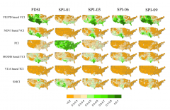
We examined the relationship between satellite measurements of solar-induced chlorophyll fluorescence (SIF) and several meteorological drought indices, including the multi-time-scale standard precipitation index (SPI) and the Palmer drought severity ......

Landsat 8, the most recently launched satellite of the series, promises to maintain the continuity of Landsat 7. However, in addition to subtle differences in sensor characteristics and vegetation index (VI) generation algorithms, VIs respond differe......
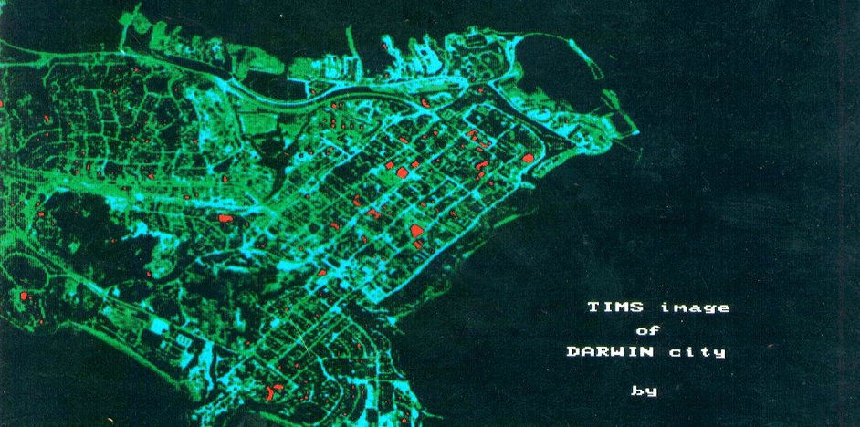
Realizing the importance of Urban Energy Waste and Urban Heat Island phenomena due to rapid urbanization not only in China but also in other parts of the world, scientists of HRSL, IRSA also conducted experiments in Darwin, Australia by using Modular......
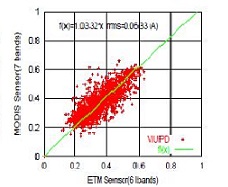
Recent study published in International Journal of Remote Sensing by Chen et al., 2013 proved the superiority of VIUPD over 12 other famous indices for Hyperion and Chris data. It is worth mentioning here that VIUPD was a brain child of the Prof. Lif......

Field Imaging Spectrometer System (FISS) was developed in 2008 by Hyperspectral Remote Sensing Laboratory of Institute of Remote Sensing Applications, Chinese Academy of Sciences as a novel spectrometer which could not only record the reflectance fro......

Core drill Imaging Spectrometer System (CISS) developed by the Institute of remote sensing and digital earth, Chinese Academy of Sciences, can be used for detection of core components and catalog, rapid retrieval and scanning cores available on the d......
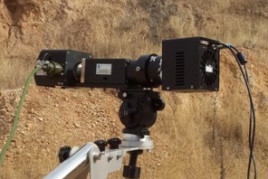
SWIR Field Imaging Spectrometer System developed by the Institute of remote sensing and digital earth, Chinese Academy of Sciences, can be flexibly mounted on the ground frame, motor vehicles, aircraft and other platforms, can obtain high resolution ......
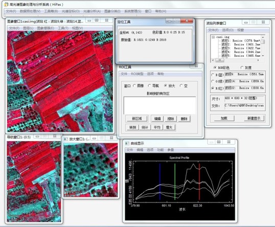
Hyperspectral image prcessing and analysis system(HIPAS) is the development of the first set software system with comletely independent intellectual property rights,supported by Chinas 863 Program, mainly for the professional image processing of hype......
Copyright © Hyperspectral Remote Sensing Application Division, RADI, CAS 京ICP备18008536号